▶ Watch Video: Ernesto strengthens to a hurricane as it rolls through Caribbean
Ernesto became a hurricane on Wednesday morning while moving through the Atlantic Ocean north of Puerto Rico, as forecasters had predicted. The National Hurricane Center upgraded Ernesto from a tropical storm once its maximum sustained winds reached 75 miles per hour, and said it could become a major hurricane in the next couple of days.
Earlier forecasts noted that Ernesto was already bringing “flooding rains” to parts of Puerto Rico and the Virgin Islands while gaining strength on a path through the Caribbean. Despite its positioning at 2 p.m. some 225 miles northwest of San Juan, the hurricane center said portions of the island remained at risk of flash flooding because rainfall was substantial and ongoing. Meteorologists had warned Wednesday morning that “significant flooding” was likely across Puerto Rico and the Virgin Islands as the storm continued to drench the region with rain.
Ernesto became the fifth named storm of the 2024 Atlantic hurricane season when it formed Monday along a fast-moving path to the Caribbean. The storm comes on the heels of Hurricane Debby, which lashed parts of the southeastern United States last week with disastrous flooding and brewed up a flash of severe weather that ultimately touched much of the East Coast. Ernesto isn’t expected to strike the U.S. mainland, the hurricane center said.

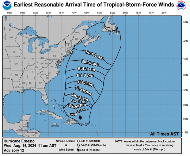
As of 2 p.m. Wednesday, forecasters said Ernesto had maximum sustained winds of 75 mph, just exceeding the 74 mph threshold that separates hurricanes and tropical storms. It was traveling northwestward at 16 mph, along a track eventually expected to take it all the way up to Bermuda.
For the time being, Ernesto remained about 805 miles south-southwest of the British island territory. The storm’s forecast track showed its center continuing to move away from Puerto Rico Wednesday, before tracking across the western Atlantic for several days and nearing Bermuda on Friday and Saturday.
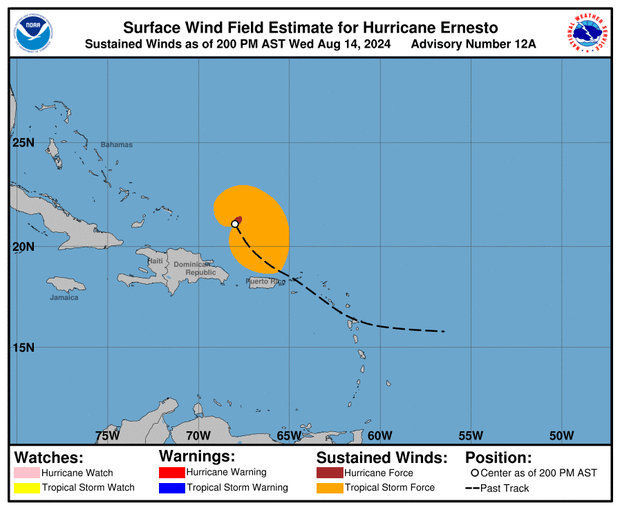
Hurricane-force winds extended outward up to 35 miles from the eye of the storm on Wednesday, while tropical-storm-force winds had splayed out up to 230 miles from the center. The latter marked a massive expansion from Ernesto’s 70-mile reach 24 hours earlier.
Tropical storm warnings and a hurricane watch that had been effective in the U.S. and British Virgin Islands, Puerto Rico, Vieques and Culebra were all discontinued Wednesday afternoon, and no coastal watches or warnings remained active after that. But meteorologists noted that Bermuda could be placed under a hurricane watch before the end of the day.
Hurricane watches are issued when hurricane conditions are possible in a given area within 12 hours or so. Tropical storm warnings are issued when forecasters expect tropical storm conditions to impact an area within 36 hours.
Meteorologists said tropical storm conditions, primarily heavy rain, were hitting those warning areas Wednesday morning and expected them to continue for several more hours. At 2 p.m., torrential downpours had been blanketing parts of Puerto Rico for much of the day, and gusty winds were forecast to persist, according to the hurricane center.
“Heavy rainfall will result in locally considerable flash flooding and mudslides today over the Virgin Islands and into portions of Puerto Rico,” the hurricane center said at 8 a.m. In an advisory issued before that, meteorologists had forecast the possibility of “minor coastal flooding” in areas affected by onshore winds along the eastern coast of Puerto Rico, including the islands of Culebra and Vieques, and the U.S. Virgin Islands, including St. Thomas, St. John and St. Croix.
Not unlike Debby, which dumped devastating and, in some instances, historic rainfall on southeastern U.S. states last week, Ernesto’s primary threat was heavy rain, although less rain was forecast for this week compared with last week’s hurricane.
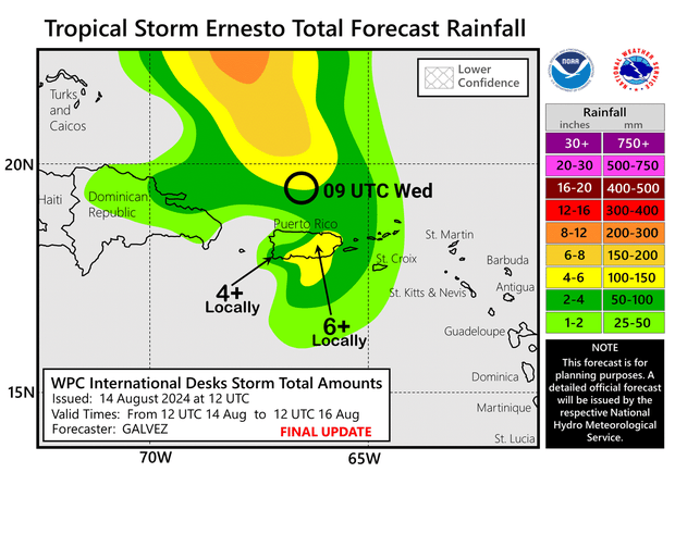
The hurricane center said the storm is expected to produce between 4 and 6 inches of rain over the U.S. and British Virgin Islands and up to 10 inches across southeastern Puerto Rico. There was “torrential rain” falling on eastern Puerto Rico Wednesday morning.
Ernesto was also forecast to drive ocean swells affecting parts of the Virgin Islands, Puerto Rico, the Dominican Republic, the Turks and Caicos and the Bahamas, before reaching Bermuda, the hurricane center said. Forecasters warned the swells would likely cause dangerous, and potentially deadly, rip currents and surf conditions.
“Even though Ernesto is forecast to remain well offshore the U.S. East Coast, swells generated by the storm are expected to reach the area late this week and into the weekend,” the hurricane center wrote in an 11 a.m. advisory. “Beach goers should be aware of a significant risk of life-threatening surf and rip currents, and stay out of the water if advised by lifeguards.”